Where and how floodwaters flow is determined by watersheds. Because watersheds ignore jurisdictional boundaries and can span multiple communities, state governments are best positioned to organize large watershed-level approaches to flood planning.
By modeling floods at the watershed level, state governments can assess risk across multiple communities. Such an approach — when informed by accurate, forward-looking data and consistent methodology — can reduce cost and time of local planning, helping build local capacity and more equitable flood resilience.
Before they invest in flood adaptation, states must understand what is at risk. And to do so, they need to identify and collect the correct data to eventually inform a plan for managing flood risk.
Bathymetry: Underwater geography of rivers, lakes, and oceans, which affects how water flows.
Topography: Elevation of physical landforms of an area, often gathered by LiDAR (light detection and ranging), which affects how water flows.
Ground cover: Physical material on the Earth’s surface, like soil and vegetation, which affects how water flows over and into the ground.
Rainfall: Historical precipitation amount and duration, gathered from monitoring stations.
Stream gauge: Historical measurements of water flow and height, gathered from gauges along a river or stream.
Sea level rise: Historical high and low tide points.
Design storm: Projections of precipitation amount — calculated at a particular location, for a given amount of time, and of a certain intensity (known as an intensity-duration-frequency curve). This estimate, which can be used to determine a flood hazard map, should be for a time period matching your planning horizon.
Sea level rise: Projections of high and low tide points. This estimate, which can be used to map coastal flood hazards and groundwater conditions, should be for a time period matching your planning horizon.
Building stock: Location and physical attributes of residential, government, commercial, and other built structures, which can be used to determine what is at risk.
Critical infrastructure: Location and physical attributes of critical infrastructure used to assess whether infrastructure is at risk of flooding.
Social vulnerability: Factors that may weaken a community’s ability to prevent human suffering and financial loss from a hazard; such factors can include economic status, racial and ethnic demographics, age, and gender.
Regulatory data: Local (or regional) regulatory buffers, overlays, or other features that prohibit or restrict activity in flood-prone areas.
Local planning data: Comprehensive master plans, zoning, planned capital improvement plans, and similar documents that guide how a community develops.
Hydrologic & hydraulic (H&H) modeling is a type of flood hazard modeling that comprises two important sciences:
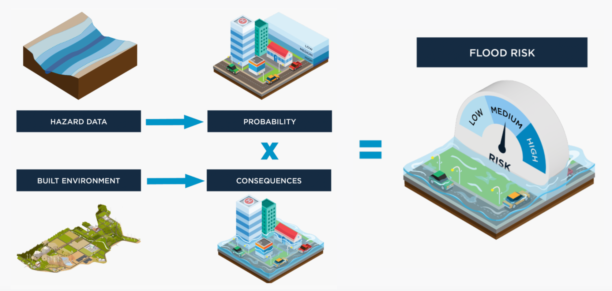
In other words, H&H modeling simulates where water is (hydrology) and where it will go (hydraulics). This modeling tends to focus on the relationship between rainfall and runoff but can cover all aspects of the hydrologic cycle. Such modeling can be used to design water infrastructure, study natural systems, regulate areas, or map floodplains. Modelers combine foundational and hazard data to conduct H&H modeling and determine the boundaries of possible flooding.
State planners should use accurate data to inform flood risk assessments. These assessments look at the likelihood of a flood (probability), combined with how that flood will affect people and property (consequence). Planners take the estimated flood boundaries from models and combine them with vulnerability and supplemental decision-making data to determine who and what will be at risk. Using these assessments, states can take proactive steps to better prepare communities for floods.
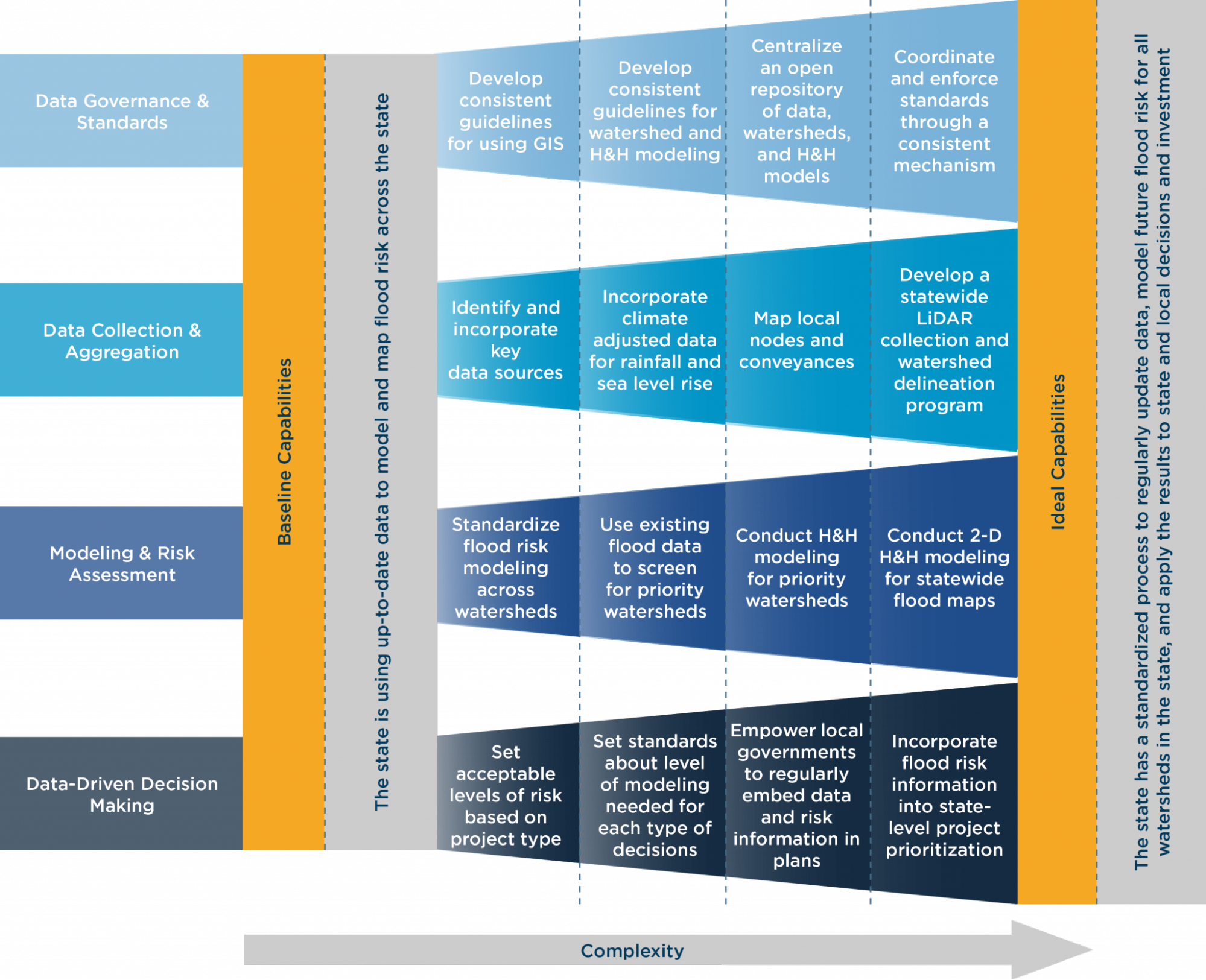
To help states improve data collection and risk assessment, the State Resilience Partnership created this Flood Risk Data Collection & Assessment Framework.
The Framework is organized into four topics, with four building blocks within each topic that become more complex as states improve data collection and risk assessments. These topics are not exhaustive, and states can implement these topics in the order that suits their needs.
The following recommendations can help states avoid common errors that governments make when approaching flood data and modeling.
Standards enable modelers to use data and build models that stand the test of time and stitch together larger models across entire states and regions. These standards ensure better modeling, smoother peer review, and a longer useful life of data and model.
Standards enable modelers to use data and build models that stand the test of time and stitch together larger models across entire states and regions. These standards ensure better modeling, smoother peer review, and a longer useful life of data and model.
Peer review ensures model quality but if such review is not possible, agencies should ensure that those running the models maintain a high level of accuracy during each step of the process. This is especially important, as modeling cannot be checked easily at the end of the process.
By engaging the public equitably and early on, states can increase the ultimate success of projects, enhance data collection, and create a network of champions who can sustain efforts in future years. In most cases, the public will be most familiar with local conditions during flooding and can provide valuable information and records.
To develop plans for long-term projects, states should build a list of model scenarios that uses future data to answer all essential questions and communicate this list to modeling teams and stakeholders.
Once they start producing results, models can be deceptively reassuring, and governments can rush into making decisions. Experts should step back and either rigorously test the model or at least examine it against best available information.
Without setting early parameters on modeling, governments can become overwhelmed with information, leading to wasted time and money and sowing confusion.
Selecting the wrong model can lead to many difficulties, including a decreased useful life of the model or data, budget issues, schedule delays, and stakeholder disputes.
Modeling and data are tools for decision making, planning, and engineering. Without effective communication, models can fail to achieve their purpose. Models are not only about numbers — they should also ensure planners have the proper answers to save lives and property.